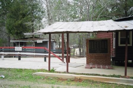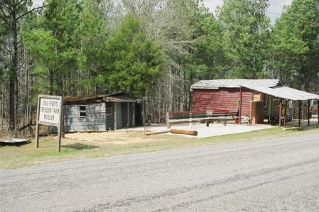
Museum
March 2006 photo:
Kim Jacobson
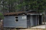
John Rice Room
March 2006 photo:
Kim Jacobson |
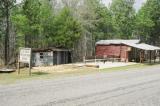
Alabama Civil Rights
Freedom Farm Museum
Judge Hughes Rd. (Co. Rd. 183)
Mantua, AL 35462
Phone: 205-372-3446
Collection of shotgun houses depicting low-income black life
1930s–1960s. Houses named for Civil Rights pioneers such as
Rosa Parks, Martin Luther King Jr., Ralph Abernathy.
Photographs, articles, other memorabilia.
|
|
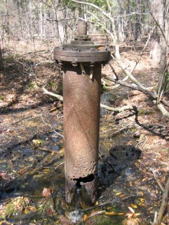
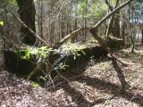
Artesian Spring at Sipsey Mills March 2006 photo:
Kim Jacobson
Remains of Sipsey Mills
March 2006 photo:
Kim Jacobson
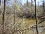
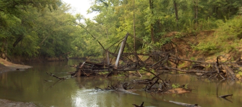
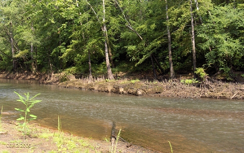
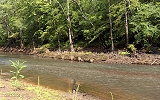
Sipsey River at Sipsey Mills site
March 2006 photo:
Kim Jacobson
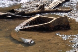
Sipsey Mills cog wheel, possibly part of the dam further
upstream. photo: Scott Owens

Remains of the iron girder bridge (c1920) located just
upstream of the mill site.
photo: Scott Owens
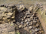
Sipsey Mills Ruins
photo: Scott Owens

photo: Scott Owens
The eight or possibly nine solid brick foundation columns are three
feet square and eight feet tall. They were four feet two inches
apart and connected by arches to form a solid foundation base
for the eighteen inch thick brick walls. The river bed
in front of the toppled foundation columns is entirely made up
of broken brick from the fallen walls of the mill. No
millstones can be found.
Another view of brick foundation columns.
photo: Scott Owens
|
Sipsey Mills
Article by Scott Owens
Jordan's and Lanier's Sipsey Mills, was a
three-story brick structure built on the steep north bank of
Sipsey River. A large, three-runner gristmill complex, it was
the largest in southern Pickens and Greene counties. William
B. Jordan, a prominent planter in the Mantua area of Pickens
County, and Thomas C. Lanier, an equally prominent planter in
Pleasant Grove, were proprietors of Sipsey Mills.
Lanier was a
colonel in the Confederate army commanding the 42nd Alabama
Infantry in the Army of Tennessee, at that time in North
Carolina. This facility had a considerable grinding capacity
of both corn and wheat; approximately 60,000 bushels of each
grain could be milled in one year. Twelve mill workers were
employed at the facility in 1860, and by 1865 the mill also
served as a Confederate Commissary Depot. Tax-in-kind pork,
mostly cured sides of bacon, recently collected in March,
filled the warehouse, as well as barrels of flour and corn
meal; these were intended for the Confederate Army of
Tennessee and Forrest's cavalry.
The mill complex, on the
southern edge of Pickens County, was situated about two miles
north of the plantation community of Pleasant Ridge in Greene
County, on the Selma-Columbus Stage Road, and just downstream
of the strategic bridge on this major thoroughfare in west
Alabama. At Pleasant Ridge the Selma-Columbus Stage Road
crossed the Vienna-Northport Road, a designated post route
which connected the river port on Tombigbee with Northport and
Tuscaloosa on the Warrior. These roads had been traversed a
week earlier by Jackson's Division of Forrest's Corps en route
to Tuscaloosa, along with Forrest himself and his escort.
Sipsey Mills
Article by Bill Horton
The old mill site was also the site of a gin at some time after the
war. It is only a mile and a half from William Horton's home.
The
mill was operated at some point by Henry Horton who later went to Clinton and
built the mill there.
According to Marcia Speir, the mill pond in Clinton was
responsible for the malaria that decimated the town and led to it's loss of
leadership in Greene County.
The mill was an undershot mill with no dam.
One summer when the water was at its lowest the post holes in the blue rock
bottom of the river could still be seen, indicating there was a wall of sorts in
the river directing the water flow under the mill wheel. The old mill rocks were
last seen in Billy Steele's back yard. Billy and I found these old rocks in
the 1940's and I pulled them out of the ditch with a tractor in the
70s. Billy asked if he could use them for a patio so I let him have them
with the understanding they would be returned if I ever had a use for
them...
The bridge crossing the river some 200 yards upstream from the
mill has collapsed, I heard, and that may be what was mistaken for a part of the
mill. I looked at the site many times during a summer when the river was less
than waist deep and never found any of the mechanical works of the mill - most
of it was probably wood anyway. This bridge was in use as late as the 1930s and
possibly in the 1940s and was still used after the first bridge across the
Sipsey at the present location was built.
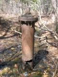
There is a massive concrete
steam engine foundation with a 6-8 inch artesian well that was still running
last time I was there. This presumably drove the gin, though it could have run
the grist mill as well, with a few belts and line shafts...
This land
north of the Sipsey was settled by William Wilder who was a neighbor of Jesse
and Amos Horton in Wake County, hence the name "Wilder Quarters". When Lanier
build the mill is not known nor is it known how he came to build it on
Wilders land. Since the courthouse fire in Carrollton destroyed all records we
will probably never know .
The road across the bridge was referred to in
Greene County documents as the "Selma to Columbus" road. The road from
Tuscaloosa to Vienna intersected this road at the mill probably making it a
good location because of the traffic and access to well traveled
roads.
This road can still be travelled, across Gulf States land leased
out to a hunting club. From the mill site the north bound road followed the
north side of the deep ditch traversing what used to be open fields. This road
hits the hills at the approximate intersection of the ditch and the highway.
There is a round dug well just off this road and at considerable elevation from
the flat fields. I was told by Efraim McKinstry, who lived all his life on
Wilder Quarters, that there was once a tavern or stage stop at this well.
From there the road winds through the rather steep red hills
some five or six miles to Junior Craft's house in Benevola.
There are
several Wilders buried in the cemetery on the Summerville place (Bethany Church
???) The road from the mill to Vienna can still be followed - although it is
difficult- and passes this church. The road from the bridge to Pleasant Ridge
can also be easily followed across Charlie Hughes' place. It crossed the Pleasant
Ridge to Lewiston road about where the tenant houses on William Steele's place are.
This road passed within yards of the old William Horton home.
I have
never been able to find any old road from Pleasant Ridge to Lewiston. There was
one leading to the Spring Hill (?)Cumberland Presyterian Church.
In
fact, there were never any old homes of the same vintage as the many "old" homes
at the Ridge, raising the question of there being anyone living in Lewiston
during the War Between the States. The Richardson home and the Ida
Lavender/Homer Carpenter homes are the oldest homes there and they were
definitely not of the same vinatage as the Grantham, Bibb, Jones, Williams, and
Burton houses at the Ridge.
Ab Jayvine, who was a black minister of some
repute, lived in an older home on the Lewiston to Clinton road not too far from
the Cumberland Presyterian church (is that the Spring Hill church?) But the
Jayvine home was hardly a part of any community.
The people buried in
the cemetery at Spring Hill include many Kings, Scarboroughs, and other families
who had ties to the Hortons and I suspect there was a well used road from the
Horton/King community to this church. I have ridden this road from Carpenter's
Store to Ab Jayvine in the forties, but with the paper company clearing and the
changes made to the Grubb's land I doubt there is any trace of this road
left. Editor note: Spring Hill is most likely Pleasant Hill Cumberland Presbyterian Church & Cemetery.
|