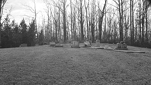
Directions to Cedar Grove Cemetery
      				Greene  County, Alabama                       
      				
  
				 | 


				| 
      				Cemetery Address | 
      			
      				 
      				Knoxville, Alabama                        
      				 
				 | 				


				| 
      				Latitude | 
      			
      				32.9856807     
      			 | 
      		
            
				| 
      				Longitude
      			 | 
      			
      				-87.7964009    
      				
  
				 | 				


				| 
      				Township/Range/Section 
      			 | 
      			
      				T23N R3E  S9 
      				
  
				 | 				


				| 
      				Directions to Cemetery | 
      			
      				I20/59 exit 52; north on 11/43/7 to first turn on left; cemetery at the end of road. Less than one mile from I20.
      				
  
      			 | 				


				| 
      				Historic Map Reference
      			 | 
      			
      				Historical Atlas of Alabama, Volume 2, Map 53 
                    -NE 
      				
  
      			 | 				


				| 
					   
      			 | 


				| 
					 Cedar Grove Cemetery 
					Page 2 
      			 |